
GROWING COMMUNITY. STEWARDING TOMORROW. • BREMERTON & KITSAP COUNTY, WA
FUTURE FARM · CONCEPT DEVELOPMENT

Five acres.
Room to grow.

Three realistic programming approaches for a future youth-centered agricultural learning site. Each explores how education, food growing, responsible animal care, and land stewardship might share a five-acre property.

NEW · PROPERTY-REFERENCED STUDY

2755 Lost Creek Lane NW: site-specific scale models

Explore two proportional five-acre test fits based on the listing’s wooded terrain, ravine and private-road access. These are preliminary area models, not surveyed site drawings.

Explore the Lost Creek study →
FEATURED SITE VISION

A place for learning, not a residence.

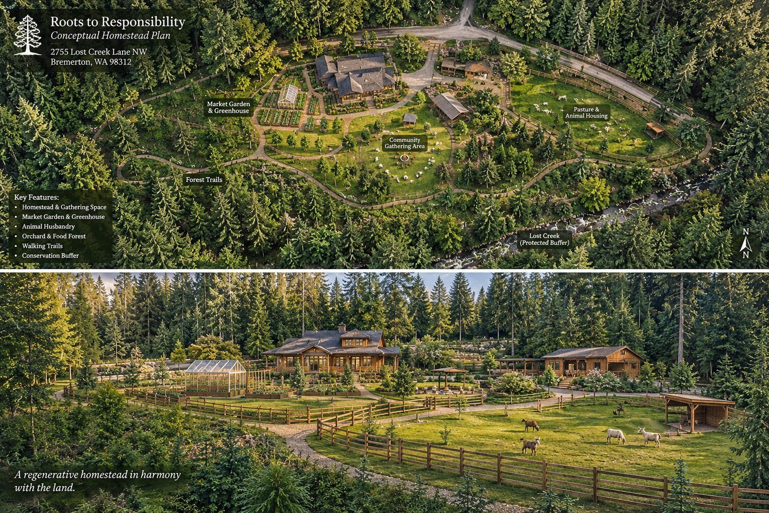
This conceptual homestead-style campus illustrates the educational and community functions we envision for a future Roots to Responsibility site: market gardens and greenhouse, an outdoor gathering area, supervised animal-care spaces, woodland trails, and a protected creek corridor.

DESIGNED FOR LEARNING

A working community classroom, not a residence.

The proposed five-acre site is envisioned as a supervised, accessible educational farm. Every building and outdoor area supports youth programs, community participation, responsible animal care, or habitat stewardship. The visual concept is aspirational and does not establish permitted uses for any particular parcel.

01 · HANDS-ON LEARNING

Outdoor classrooms

A covered, open-air teaching pavilion with tables, handwashing access, weather protection, and a gathering point for school groups. A flexible outdoor circle supports demonstrations and reflection.

02 · FOOD & GROWING

Student garden plots

Accessible raised beds, seasonal teaching plots, composting, an orchard, and a modest greenhouse help students learn about soil, food systems, and stewardship.

03 · ANIMAL WELFARE

Supervised animal care

Separate fenced teaching zones, appropriate shelter, sanitation, animal rest areas, and secure gates. Animal activities would begin only after permits, staffing, veterinary protocols, and funding are in place.

04 · COMMUNITY

Accessible gathering spaces

Step-free routes where feasible, clear wayfinding, seating, shade, and designated drop-off areas create welcoming opportunities for families and volunteers.

05 · LAND STEWARDSHIP

Trails and habitat

Low-impact interpretive trails and woodland education areas encourage ecological learning while respecting sensitive habitat and any legally required creek or wetland buffers.

06 · SAFE OPERATIONS

Program support facilities

Tool storage, handwashing and restroom facilities, first-aid supplies, secure equipment areas, and emergency access are integral to a youth-serving campus.

THE PLANNING FRAMEWORK

Three possible directions

A five-acre parcel contains 217,800 square feet. To make the concepts comparable, each diagram assumes a hypothetical 660 × 330-foot rectangle with road access on one edge. Real parcels are rarely this simple.

CONCEPT 01

Education-first campus

A practical early-phase layout prioritizing safe access, school groups and garden-based learning.

FIVE-ACRE CONCEPT • LAND ALLOCATIONIllustrative proportions • not a property survey010203040506Refer to the numbered key and acreage table below.
01Arrival & parking0.35 ac
02Learning pavilion & paths0.45 ac
03Teaching gardens & orchard1.25 ac
04Small animal learning zone0.55 ac
05Open field & future expansion1.10 ac
06Woodland & habitat buffer1.30 ac

Areas are approximate programming allocations, not verified buildable areas. Illustrative north arrow and rectangular geometry are hypothetical.

Land-use allocation

ZoneAcresSq ft
Arrival & parking0.3515,246
Learning pavilion & paths0.4519,602
Teaching gardens & orchard1.2554,450
Small animal learning zone0.5523,958
Open field & future expansion1.1047,916
Woodland & habitat buffer1.3056,628
Total5.00217,800

Planning priorities

  • Parking and drop-off remain close to the entrance
  • Teaching beds and covered learning area form the core
  • Small livestock zone stays separated from food growing and children’s arrival
CONCEPT 02

Animal stewardship farm

A balanced approach with managed paddocks and animal-care teaching, alongside food production.

FIVE-ACRE CONCEPT • LAND ALLOCATIONIllustrative proportions • not a property survey010203040506Refer to the numbered key and acreage table below.
01Arrival & support buildings0.45 ac
02Gardens & orchard0.85 ac
03Barn, yard & quarantine0.50 ac
04Rotational paddocks1.65 ac
05Outdoor classroom & trails0.35 ac
06Woodland & habitat buffer1.20 ac

Areas are approximate programming allocations, not verified buildable areas. Illustrative north arrow and rectangular geometry are hypothetical.

Land-use allocation

ZoneAcresSq ft
Arrival & support buildings0.4519,602
Gardens & orchard0.8537,026
Barn, yard & quarantine0.5021,780
Rotational paddocks1.6571,874
Outdoor classroom & trails0.3515,246
Woodland & habitat buffer1.2052,272
Total5.00217,800

Planning priorities

  • Paddocks allow rotational use but not assumed year-round forage sufficiency
  • Animal facilities require manure management, water and secure fencing
  • Horses would require a separate feasibility review and additional feed capacity
CONCEPT 03

Conservation-led learning farm

Preserves more wooded habitat and offers a lighter-touch phased development approach.

FIVE-ACRE CONCEPT • LAND ALLOCATIONIllustrative proportions • not a property survey010203040506Refer to the numbered key and acreage table below.
01Arrival & accessible facilities0.30 ac
02Teaching gardens0.70 ac
03Outdoor classroom & gathering0.30 ac
04Small animal demonstration0.35 ac
05Meadow, orchard & trails0.85 ac
06Woodland & ecological buffer2.50 ac

Areas are approximate programming allocations, not verified buildable areas. Illustrative north arrow and rectangular geometry are hypothetical.

Land-use allocation

ZoneAcresSq ft
Arrival & accessible facilities0.3013,068
Teaching gardens0.7030,492
Outdoor classroom & gathering0.3013,068
Small animal demonstration0.3515,246
Meadow, orchard & trails0.8537,026
Woodland & ecological buffer2.50108,900
Total5.00217,800

Planning priorities

  • Keeps roughly half the parcel in woodland or ecological buffer
  • Supports nature walks, habitat education and a smaller initial footprint
  • Potentially best suited to constrained or partially forested sites
PHASED IMPLEMENTATION

Start small. Build responsibly.

PHASE 1

Site readiness

Due diligence, access, utilities, accessible paths, garden beds, water supply, safety procedures, and a small outdoor gathering area.

PHASE 2

Learning expansion

Covered classroom, orchard, tool storage, compost systems, additional garden plots, and habitat restoration.

PHASE 3

Animal facilities

Only after funding, permits, animal-welfare protocols, manure planning, fencing, and operating capacity are established.

SITE DUE DILIGENCE

What must be verified before building

Land and permits

Boundary survey, zoning and allowed uses, critical areas and wetland buffers, tree removal rules, setbacks, stormwater, driveway/fire access, building and land-disturbance permits.

Operations and safety

Soil tests, water availability, wastewater and sanitation, ADA-accessible routes, child safeguarding, livestock fencing and shelter, manure handling, emergency access, insurance, and ongoing maintenance.

These are illustrative land-use scenarios, not architectural floor plans or an assessment of any specific Kitsap County parcel. Acreage allocations include conceptual circulation and support space but do not establish buildability. A local surveyor, land-use planner, engineer, and relevant county agencies must review any selected site before commitments or construction.